


LOCAL HISTORY | ELMWOOD PARK
The River We Cross: Indigenous History Along the Des Plaines
A familiar river. A much deeper history. And a reason to pay closer attention to the place we call home.
I’ve lived in Chicago’s western suburbs my whole life, and I’m still learning how much history is hiding in plain sight.
Case in point: the Des Plaines River.
For a lot of us, it’s the river we cross on the way somewhere else. A place to walk through the forest preserves. Occasionally, a reason to worry about flooding. But an old map of Indigenous villages and trails around Chicago made me stop and reconsider the landscape I thought I knew.
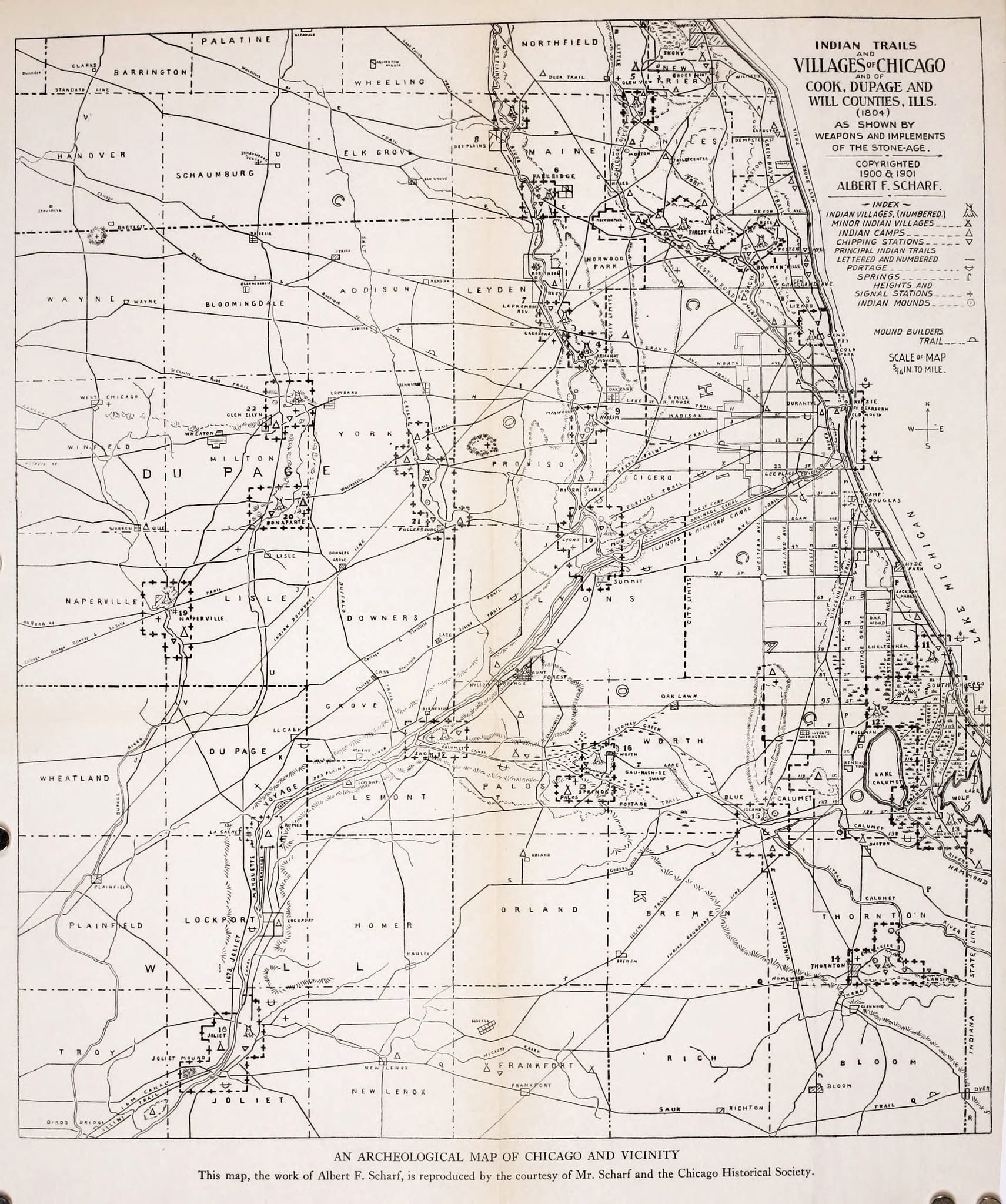
Along the river, the map records villages, camps, trails, toolmaking sites, and mounds. Suddenly, a familiar stretch of the western suburbs looks a lot less familiar.
Reading the map carefully
The map was compiled by Albert F. Scharf in 1900–1901 to reconstruct an earlier landscape associated with 1804. That distinction matters. It combines archaeological evidence and historical information rather than giving us a firsthand survey of every community in one particular year.
A later study published in Mapline compared Scharf’s trails with early federal survey maps and found considerable agreement, while acknowledging the map’s limitations. It’s a useful starting point, with plenty of questions still attached. 1
The symbols also mean different things. A camp isn’t necessarily a permanent village. A toolmaking site doesn’t establish the size of a settlement. And a mark near Elmwood Park doesn’t automatically fall inside today’s village boundaries.
What the map does show is a connected landscape with a substantial history along the Des Plaines.
Elmwood Park’s history reaches beyond 1914
The Encyclopedia of Chicago’s Elmwood Park entry mentions Indigenous toolmaking and mound construction along the river’s bluffs. It then moves into the familiar local story of farming in the 1840s, railroad development, and the village’s incorporation in 1914. 2
That brief reference deserves more attention.
Our municipal history has a starting date. The history of the land does not begin there. The archaeological sites along the river point to lives and activities that preceded the farms, subdivisions, and streets we know today.
The map’s cluster of sites helps us imagine that earlier landscape. Today, we sort this area into Elmwood Park, River Grove, Franklin Park, and neighboring communities. Those boundaries came much later than the Indigenous routes and settlements recorded here.
People and places behind the symbols
Potawatomi people were central to the Chicago region’s late 1700s and early 1800s history. Odawa and Ojibwe communities were also part of the region’s history and treaty relationships. Older archaeological sites cannot automatically be assigned to those same communities. 3
Nearby records give us individual names, too. Franklin Park Public Library describes Claude LaFramboise’s reserve north of Grand Avenue in the Des Plaines corridor. Alexander Robinson, also known as Che Che Pin Qua, had a nearby landholding, and his family’s homestead and burial grounds are marked at Robinson Woods. 4, 5
These details bring people back into a map that can otherwise feel like a collection of symbols. Families lived here. People knew these places, traveled between them, and built lives on this land.
The part between Native communities and settler farms
Local histories often move quickly from Indigenous presence to European American settlement. That transition needs more explanation.
The 1833 Treaty of Chicago involved a vast land cession and helped establish the framework for large-scale Potawatomi removal westward. The Citizen Potawatomi Nation’s Cultural Heritage Center describes the agreement as a watershed in the Nation’s dealings with the US government. 6
The Encyclopedia of Chicago also records remaining Chicago Potawatomi gathering at a camp on the Des Plaines River before departing in 1837. I haven’t established that camp’s precise location, so I won’t place it in Elmwood Park. But the river’s place in that regional removal history is documented. 3
The farms and subdivisions followed land loss and removal. Understanding that makes the familiar local timeline more honest.
Indigenous Chicago continues
Native history here is also a living story. The American Indian Center, established in Chicago in 1953, continues to serve Native communities. Indigenous Chicago’s digital resources connect historical places with the region’s ongoing Indigenous presence. 7, 8
What this has to do with our gardens
I’m also looking at this as someone who plants native flowers and grows vegetables in an Elmwood Park backyard. It’s easy to get absorbed in what will fit in a bed or survive the dogs. I spend considerably less time thinking about how the food I’m planting came to be.
Corn, beans, and squash have long been grown together in Indigenous agricultural traditions. There’s knowledge in those planting relationships, developed and passed on by people paying close attention to crops and growing conditions. Those histories deserve a place in our conversations about gardening, too. 13
Native gardening has made me more interested in caring for the place I live. Learning about Indigenous growers pushes me to think beyond my own little patch: Who has access to land? Who gets to make decisions about it? Whose knowledge gets recognized?
There’s work to support right now
Today is Indigenous Peoples’ Day, and there’s a nearby example worth knowing about. The American Indian Center purchased 6.5 acres near Woodstock along Nippersink Creek in August 2026. Its plans include habitat restoration, seed gathering, and education. This is a separate watershed from the Des Plaines, but part of the region’s living Indigenous story. 10
The Indigenous Seed Keepers Network, a program of the Native American Food Sovereignty Alliance, supports communities protecting ancestral seeds and strengthening Indigenous foodways. Food sovereignty includes the ability of communities to make decisions about their own food systems. 11, 12
I can put native plants in my yard and still have plenty to learn about the people whose homelands I share. These organizations give me somewhere to start, and somewhere to direct support.
We can read what Native educators choose to share, contribute when we’re able, and follow Native-led organizations’ requests. If volunteering is welcome, show up for the work they’ve identified. Let the people doing it set the priorities.
For anyone curious about our corner of the western suburbs, the Indigenous Chicago village map is a useful place to begin. Its own guidance acknowledges that the evidence is incomplete. Elmwood Park Public Library’s Local History Room is another place to pursue questions about recorded sites, local finds, and the history of the river bluffs. 8, 9
As a Realtor, I spend a lot of time talking about what makes a place special. Architecture, neighborhoods, parks, and the people who live here all matter. So does learning the history that came before the familiar version.
I’ll still cross the Des Plaines on my way somewhere else. But I’ll be paying a little more attention to where I already am, and to what I can do with what I’m learning.
LEARN · LISTEN · SUPPORT
Native-led work worth knowing
Sources and further reading
- Carl Kupfer and David Buisseret, “Indian Trails in the Chicago Region,” Mapline 132, pp. 11–14
- Encyclopedia of Chicago, “Elmwood Park, IL”
- Encyclopedia of Chicago, “Potawatomis”
- Franklin Park Public Library, “Native American Settlement of the Franklin Park Area” (Used for nearby reserve geography; other details in this older local account require independent checking.)
- Forest Preserves of Cook County, “Robinson Woods”
- Citizen Potawatomi Nation Cultural Heritage Center, “Platte Purchase, Missouri”
- American Indian Center, “About Us”
- Indigenous Chicago, “Village Sites Map”
- Elmwood Park Public Library, “Local History Room”
- American Indian Center, “2026 Gala — Rematriation: Land Back, Life Forward” (documents the August 2026 purchase)
- Native American Food Sovereignty Alliance, “Indigenous Seed Keepers Network”
- Native American Food Sovereignty Alliance, “Giving”
- Smithsonian Folklife Festival / National Museum of the American Indian, “Corn, Beans, and Squash: What the Three Sisters Tell Us”